Policy SPS5.10: Overton Mill, Overton
Closed22 Jan, 2024, 10:00am - 4 Mar, 2024, 11:59pm
Policy SPS5.10: Overton MillThe site, as shown on the Policies Map, is allocated for a well-designed and sustainable development that will:
Infrastructure
|
| 6.130 | The allocation, which is located to the north of Overton village, in close proximity to Quidhampton, comprises of two separate parcels of previously developed land, which are dissected by Overton Train Station and the railway line that runs in an east to west direction. The land to the north of the railway line was the location of the now disused Overton paper mill and associated office buildings. The land to the south includes a former water treatment facility associated with the operation of the mill. The site is allocated for approximately 340 homes, which are to be provided via a range of suitable dwelling types and tenures including 40% affordable housing. New small scale employment (Class E(g), B2 and B8), and retail (Class E) uses, in addition to a parking facility for the station, will be provided within close proximity to Overton Railway Station. Development will be supported by the timely delivery of supporting infrastructure including open space. Proposals for the site will be design-led and the vision for the development should demonstrate a high quality and comprehensive approach to the layout and appearance of the housing. |
| 6.131 | That part of the site that lies to the north of the railway line, and the residential part of the site to the south of the railway line, will be accessed via Papermill Lane. The employment, retail and parking facilities to the south will be accessed from Station Hill/Approach. Kingsclere Road (B3051) will be used to access the northern parcel of land by emergency vehicles only. It will need to be demonstrated that the development related traffic can be satisfactorily accommodated without detriment to the safe operation of Papermill Lane, particularly where the road narrows under the railway bridge. Pedestrian and cycle improvements are needed to link the site to facilities in Overton to the south. Any scheme will therefore include measures to increase active travel through improved links to local services and facilities, as well as the existing pedestrian and cycle networks, and encourage increased public transport use. A site wide Travel Plan will need to be submitted to minimise car use and deliver sustainable transport objectives. A Public Right of Way runs through the northern parcel of land from north to south. Such connections should be expanded, wherever possible, to maximise opportunities for active travel. |
| 6.132 | Development of the site must not have an adverse impact on the landscape qualities of the area including the North Wessex Downs National Landscape, which includes the part of the allocation which lies to the north of the railway line. The allocation provides the opportunity to enhance the rural character of the area, given the previous use of the site, and particular regard must be had to views to, from and within the National Landscape, including from Public Rights of Way and viewpoints in the wider countryside of the North Wessex Downs. Existing tree belts and groups of trees in both the northern and southern parts of the site should be retained and enhanced to limit the visual impact of development. Development must also not harm the setting of the Test Valley Valued Landscape which adjoins the eastern and southern boundaries of the parcel to the south of the railway line. Proposals must incorporate a landscape lead approach and should be informed by a coordinated and integrated approach to green infrastructure provision with suitable links to adjoining areas. |
| 6.133 | The scale of new housing development should be predominantly of no more than 2-storeys in height with consideration being given to the limited use of buildings of 2.5 or 3-storeys provided that this does not harm the rural setting of the site. This is to mitigate the impact of the development on the North Wessex Downs National Landscape to the north, the Test Valley Valued Landscape, Overton Conservation Area and neighbouring listed buildings and the general character of the area. Higher density of potentially up to 2.5 or 3-storeys may be considered adjacent to the Railway Station within the northern part of land, subject to the findings of a landscape character and visual impact assessment. |
| 6.134 | It will be important to ensure that there are no unjustified adverse impacts on the setting of neighbouring heritage assets including Overton Conservation Area and a number of listed buildings including Quidhampton Farmhouse. The impact on any potentially affected heritage asset in the area will need to be considered including two scheduled Monuments to the north of the site, and Laverstoke Park Historic Park and Garden to the south-west. These impacts, and any potential mitigation measures, will need to be considered in a Heritage Statement. |
| 6.135 | A Site of Importance for Nature Conservation (SINC) adjoins the western boundary of the northern parcel of land designated for its chalk grassland assemblage. In addition, the River Test SSSI is located to the south of the site which meanders between Quidhampton and Overton. The site is located within the SSSI risk zone and contains woodland recorded as deciduous woodland priority habitat to the north and south of the railway line. This feature will need detailed surveys to assess its value and condition as well as its potential to support protected species, including dormice. Any proposals should provide connectivity to the wider wooded features of the local landscape. |
| 6.136 | The land to the north of the railway line comprises, and lies adjacent to, the farmed areas of the North Wessex Downs, which support strong populations of European hare and skylark. Surveys will be required to identify local populations to ensure impacts to these species are mitigated and enhancements are provided. Surveys will be required to confirm the quality and condition of the grassland assets on the land to the south of the railway line. As the site previously comprised water extraction and storage on site, further surveys will be required to consider how any future use may impact upon the flows and habitats within and surrounding the River Test. A minimum of 10% biodiversity net gain will be provided on site and this will need to be achieved in a manner which reflects the mitigation hierarchy (avoid, minimise, remediate, compensate). |
| 6.137 | Water quality is an important issue given that the site drains to the River Test catchment where it is necessary to ensure that nitrate neutrality is achieved through on-site mitigation measures. Off-site measures would only be acceptable if it can be robustly demonstrated that on-site measures are not appropriate. Development will not be consented until it has been demonstrated that acceptable arrangements are in place for ensuring the appropriate disposal of wastewater. |
| 6.138 | The land parcels to the north and south are divided by a railway line and any noise pollution affecting new homes and amenity spaces will need to be mitigated. A detailed noise assessment will be required to ensure acceptable noise standards can be met and mitigation measures may be required. |
| 6.139 | A Mineral Resource Assessment will need to be submitted as part of the southern land parcel lies within a Mineral Safeguarding Area. The site also has the potential to be contaminated due to its former use as a paper mill. Some remedial measures may be required to ensure that any contamination does not pose an unacceptable risk to human health. Pre-commencement land conditions will be required as part of any planning permission. |
| 6.140 | Overton Railway Station is used by rail users from the wider area and, consequently, parking facilities can be oversubscribed at peak times, leading to overspill and indiscriminate parking, including in adjacent roads and within the site itself. In order for the development to provide safe, convenient and suitable access for all users, the design of the development needs to include parking facilities for railway users. This would benefit from an independent access from Station Hill/Station Approach to segregate these activities from the remainder of the development (including the proposed new residential areas and streets). The development should deliver a sufficient level of railway parking proportionate to the needs of the railway users. |
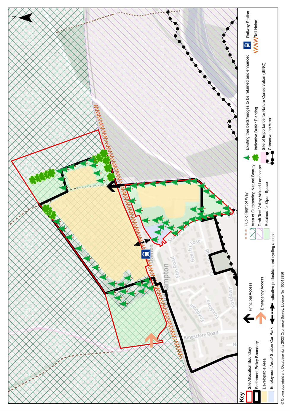
Figure 6.11: SPS5.10: Overton Mill Concept Plan
Representations
35 representations have raised comments relating to this chapter