Policy SPS5.4: Southern Manydown
Policy SPS5.4: Southern Manydown
Vision for Southern Manydown
| 6.43 | The council adopted a Vision for Land North of the M3 at Junction 7 in March 2021. This sets the direction for future planning policy in south-west Basingstoke, including the land within the Southern Manydown site. The following is an update of that document’s long-term vision for the wider area: |
|
Land north of the M3 at junction 7 will be a dynamic, healthy and sustainable net zero carbon new community with excellent transport links. Adjoining and integrated with beautiful countryside, it will be a location for creative and inspiring growth. Land north of the M3 at junction 7 will create:
|
| 6.44 | The Vision document has been used to inform the policy approach for Southern Manydown. |
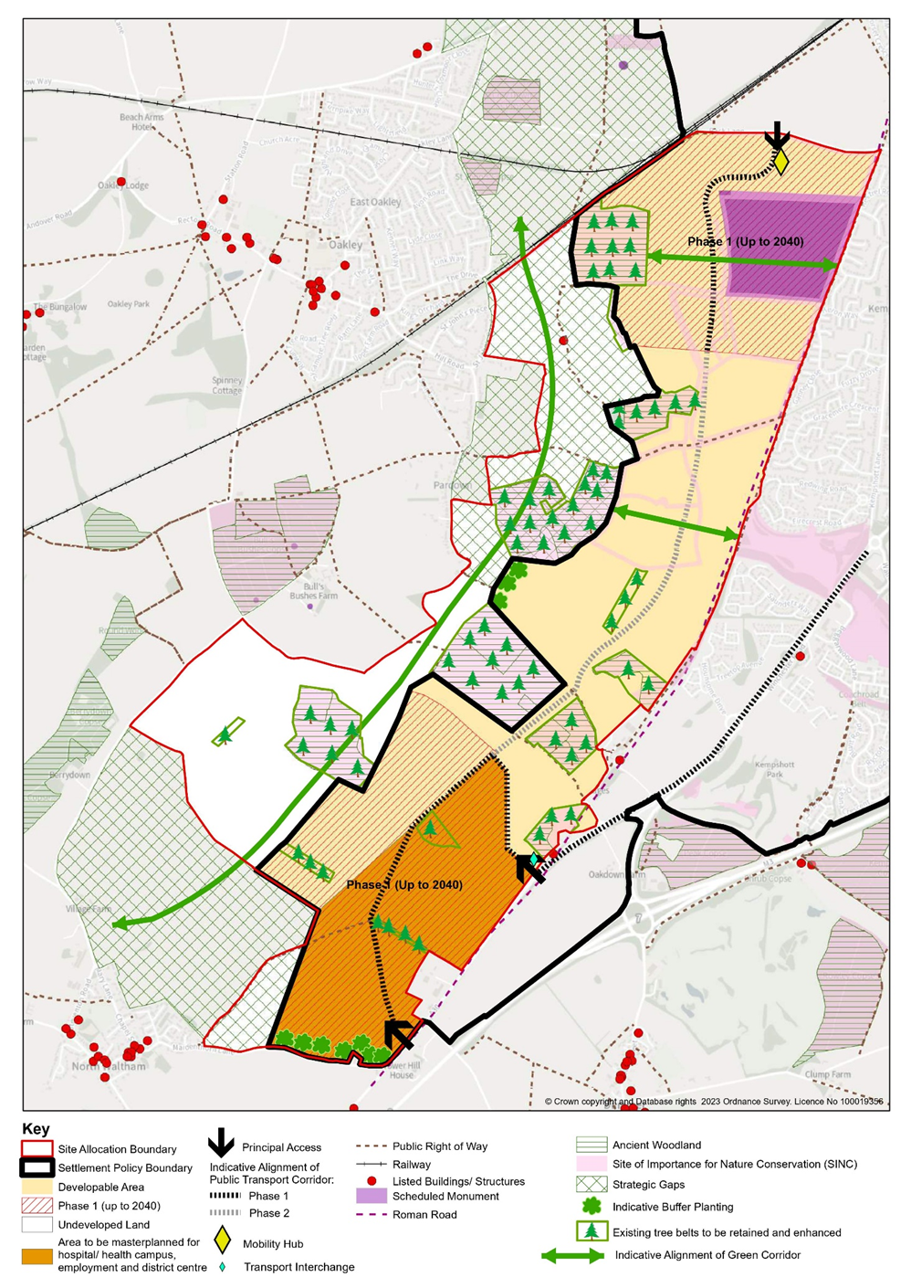
Policy SPS5.4: Southern ManydownSouthern Manydown, as shown on the Policies Map is allocated for a well-designed and sustainable development that will: Amount and Type of Development
Development Principles Masterplanning
Design and Landscape
Biodiversity
Heritage
Flooding and Pollution
Infrastructure
Energy o. Incorporate renewable and low carbon energy technologies including utilising opportunities for district heating using waste heat generated by the hospital and health campus; Social and community
Green Infrastructure
Transport
Utilities
|
| 6.45 | Southern Manydown provides an opportunity to deliver a strategic-scale sustainable development that will provide for a significant proportion of the borough’s housing needs, within this Plan period and beyond. The scale of the development will allow the creation of an infrastructure-rich and healthy net zero carbon new community through exemplar design that will proactively address the council’s Climate Change and Ecological emergencies. |
| 6.46 | In its totality, the site can accommodate up to 7,500 new homes, and it is expected that approximately 2,400 homes, including a significant number of affordable homes, will be delivered in the Plan period along with supporting community and social infrastructure. It is anticipated that the first housing could be delivered from 2032, and there is an opportunity for the landowners to bring forward development at both the northern and southern ends of the site to increase the delivery rate within the plan period. The Concept Plan identifies land with capacity to deliver more than 2,400 homes in the first phase (up to 2040) to provide flexibility to respond to site circumstances. |
| 6.47 | In addition to housing, a new health campus and a range of employment uses may also be accommodated at the southern end of the site close to junction 7 of the M3 and the A30. The health campus will include a new specialist hospital alongside other services and research facilities allowing mutual cooperation and innovation, and will require a helipad. The employment uses will include storage and distribution floorspace, as well as industrial and office floorspace, to meet needs. This part of the site would be subject to detailed masterplanning, and the new hospital would need to be well connected by public transport and have easy access to local retail, services and facilities for both staff and visitors. |
Masterplanning and infrastructure principles
| 6.48 | The scale and complexity of planning the future of Southern Manydown requires that a series of stages to be followed to ensure a coordinated approach to development. This will ensure that the site and its individual phases are developed comprehensively and delivered to a consistently high standard. |
| 6.49 | The Concept Plan provides a broad overview of how the site is expected to be developed within the Plan period, set within a wider vision for the site. |
| 6.50 | In advance of the pre-submission (Regulation 19) consultation, the council will work with the site promoters to produce a more detailed masterplan that will be adopted as an appendix to the Plan. This will be informed by the site promoter's emerging Sustainable Transport Strategy and provide a more detailed framework to guide future planning applications. This masterplan will include a site wide Framework Plan, Parameter Plans, an Overarching Principles Document, Phasing Strategy and details of the infrastructure required (including on and off-site transport improvements), including its timing, funding and the responsibilities for its delivery. |
| 6.51 | Through the planning process, site-wide frameworks and strategies will be required to be produced to ensure a comprehensive approach to the planning of the site and the delivery of infrastructure. These will be supported by a Strategic Design Code. The Strategic Design Code will be produced either by the Local Planning Authority (LPA), or the developer in agreement with the LPA, and adopted as a Supplementary Planning Document prior to the submission of the first full or reserved matters planning application. This approach will ensure consistent quality and delivery across the site by different developers. |
| 6.52 | The site is within the ownership of two separate landowners, and it will be necessary to ensure a coordinated approach is taken to deliver the necessary infrastructure, facilities and services to meets the needs of the new community. Suitable infrastructure will be provided when it is required, and the landowners will jointly produce an Infrastructure Delivery Strategy to demonstrate that its provision has been coordinated and fairly shared. |
Landscape-led design
| 6.53 | Southern Manydown will be a distinctive and well-designed development that will respond to its environmental setting and wider spatial context and create an attractive gateway into Basingstoke. The site will be well integrated with the other developments taking place to the west of Basingstoke (including northern Manydown which has consent for up to 3,520 dwellings and the land north of Pack Lane) to provide a comprehensive and cohesive expansion to the west of the town. |
| 6.54 | The development will have a focus upon people and the provision of local facilities and services to meet the majority of people’s day to day needs, including a network of centres in accessible locations to create walkable neighbourhoods. |
| 6.55 | The design, layout and scale of the development will be landscape-led, and its structure will be informed by the local topography including ridgelines and other landscape features. The land rises from the north and the south to a high point around South Wood, and it will be important to consider the impact of development on the higher land and more visible slopes. It will be particularly important to ensure that taller and larger-scale buildings, such as the employment buildings, hospital, and the district centre, respond to these sensitivities. A Landscape and Visual Impact Assessment will be required to inform the development and layout, to ensure there would be no significant impacts on longer distance views, including from the North Wessex Downs National Landscape, public rights of way and surrounding villages. As a general principle, higher storey heights and densities within residential areas will usually be expected around centres, and along public transport routes, with lower density development in more peripheral areas and on the rural edge. The site’s natural features will inform unique character areas that will create a legible, distinctive place. |
| 6.56 | In order to ensure there is an appropriate transition to the countryside and to avoid a hard edge to development, the layout along the edges of the site need should be of a lower density and scale with a greater separation between buildings. Open spaces along the edge should incorporate suitable levels of planting (including trees and hedging) to help give a soft transition to the countryside. Development will need to face out to the countryside to provide active frontages, with no rear gardens facing outwards and also avoid prominent parking areas on the edge of the site. The site allocation includes undeveloped land, which contributes to the green infrastructure network, and can be used to accommodate biodiversity enhancements and some types of natural greenspace. |
| 6.57 | The development will be well integrated with western Basingstoke but will retain its separation from surrounding rural settlements. Strategic Gaps have been identified between the site and North Waltham and Oakley to prevent coalescence. These gaps also contribute to the site’s green infrastructure network but are unlikely to be suitable for uses with a more urban character such as sports pitches or allotments. |
| 6.58 | Reinforced planting (at least 30m deep) will be required in key locations along the edge of the Oakley Strategic Gap and on the northern edge of Maidenthorn Lane to screen and soften the appearance of development. |
Biodiversity
| 6.59 | The site supports high levels of biodiversity and contains a number of Sites of Importance for Nature Conservation (SINCs), including ancient woodlands and those designated for rare arable flora. Notable and protected species are known to be located on or around the site, such as farmland birds, dormice and bats. The site’s layout will be underpinned by an understanding of the site’s existing ecology and green infrastructure, including those areas not previously assessed for SINC status, so that important areas for biodiversity are avoided and opportunities to protect and enhance key ecological features and species are taken. |
| 6.60 | It is expected that the ancient woodlands will be protected from indirect impacts such as recreational pressure and pet predation and will have substantial buffers to help ensure development does not result in their deterioration. Where rare arable flora would be lost, mitigation should be provided. It will be expected that the development will not result in an overall reduction in the area and spread of rare arable plants. |
| 6.61 | Opportunities to enhance existing habitats will need to be taken and the masterplan will identify opportunities to improve habitat connectivity within and beyond the site on a landscape scale, including through the creation of north-south and east-west ecological corridors that will connect the existing woodland blocks. It will be necessary for the development to achieve a minimum 10% measurable biodiversity net gain on site, or in combination with off-site measures where necessary and where impacts to biodiversity features on site have been shown to be unavoidable. Any such biodiversity net gain calculations will need to take full account of indirect impacts on the habitat features within and/or adjacent to the site separately so that a genuine net gain can be demonstrated. |
Heritage
| 6.62 | Development must also respect heritage including retaining, protecting and positively responding to the Battledown Scheduled Monument, an Iron Age settlement within the site. This is likely to require the use of appropriate buffers and a sensitive landscape strategy. A Roman road forms the eastern boundary of the site and this and other components of the historic landscape should be retained within the site’s green infrastructure. The site contains other areas of archaeological potential, some of which may need to be retained in situ, and the masterplan should respond to any sub-surface heritage assets according to their level of significance. Where archaeological assets are agreed not to be retained they will be subject to mitigation by recording with appropriate community engagement. |
| 6.63 | It will also be necessary to ensure development preserves the significance, character and appearance of other local heritage assets, including the rural setting of the conservation areas in Dummer, North Waltham and Church Oakley. There are also two Grade II Listed Buildings within the site which should be retained within sufficient space and buffered from new development to preserve their sense of rural setting and context. |
Infrastructure
| 6.64 | The centres will provide a mix of uses to meet local needs and foster healthy and sustainable lifestyles, and will be well connected by active travel and by public transport. The development will also include a new district centre at the southern end of the site that will accommodate a range of E-class and community uses. Within these centres, the amount of retail floorspace will be commensurate to the centres’ sizes, and not have a significant adverse impact upon existing centres. Given the lack of retail capacity in the plan period, it is expected that the majority of the retail floorspace will come forward outside the plan period. |
| 6.65 | The development will include on-site infrastructure to support and develop the new community including schools, community facilities, healthcare uses, sports and leisure facilities, and green uses as set out in the council’s Infrastructure Delivery Plan. The infrastructure will be suitably phased to ensure it is available at the time it is needed. As development will be phased from the northern and southern ends of the site, it will be necessary to ensure suitable facilities are easily accessible via active travel and public transport to all residents when they occupy their homes. The design and location of these facilities should take into account their future management, and it is expected that the sports pitches will be grouped and co-located with community facilities to form ‘sports hubs’. |
| 6.66 | The development will include affordable housing, older persons’ accommodation, plots for custom and self-build housing, and gypsy and traveller pitches to create a diverse and sustainable new community. It is expected that older persons’ accommodation will be provided in or near the centres where there is the best access to facilities and services. The plots for custom and self-build housing should be brought forward in groups to create distinct custom and self-build areas. |
| 6.67 | Opportunities for district heating using waste heat from the hospital and health campus should be investigated fully by the applicant to determine its feasibility and viability. It will also be necessary to demonstrate that suitable utilities can be provided in a timely manner that provides minimal disruption to local residents. |
Transport
| 6.68 | Development proposals will need to be informed by a robust and comprehensive site-specific Transport Assessment and supporting Travel Plan, which takes into account the totality of the development. This must set out an ambitious strategy to reduce the need to travel and to internalise trips, whilst maximising opportunities for active travel and public transport use to achieve mode share targets in line with Garden City Principles. |
| 6.69 | To achieve these, the site’s internal design will need to include measures to minimise the transport impacts arising from the development, including layouts and street designs that give priority to travel by active travel (walking and cycling) and public transport services within and beyond the site, and to serve the residents and users of the first phases of development at the southern and northern parts of the site, and subsequent phases thereafter. A continuous public transport and active travel corridor will be completed beyond the plan period and run through the site from near the A30 towards Pack Lane providing regular and direct connections to Basingstoke town centre and other key destinations. There is also an opportunity for the public transport and active travel corridor to connect to northern Manydown with a crossing of the railway line. To support this, traffic management measures will be needed to prevent the creation of a through route by general traffic between the A30 and Pack Lane. Therefore, vehicle journeys between the northern and southern parts of the development will need to use the external highway network, with the exception of public transport services. |
| 6.70 |
To encourage active travel and public transport services, the development will provide a high quality dedicated pedestrian and cycle network that will provide safe, suitable and convenient access to the local facilities and services necessary to enable residents to meet their day-to-day needs, and connect with neighbouring developments and communities, Basingstoke town centre (including the Basingstoke Railway and Bus Stations) and other key destinations such as the country park in northern Manydown and the Basingstoke Leisure Park. The active modes network will also be integrated with the public transport services, including accessible and safe boarding and waiting facilities (including Mobility Hubs). The Mobility Hub and transport interchange (including park and ride) will provide high quality and accessible facilities that act as focal points for public and shared transport, including supporting facilities such as car club parking, EV charging facilities for visitors, secure cycle parking and other measures to provide focal points for public and shared transport and access to attractive public transport services for travel within and beyond the site. The hub should be sensitive to its setting in terms of design and layout, and incorporate green features to minimise hard standing. |
| 6.71 | A parking strategy will be required that sets out the approach to ensuring that the parking provisions across this site will be well designed and available in the right locations. The design of the various parking facilities for all users will need to respond positively to the character and appearance of the street scene and the surrounding area, whilst reflecting the different levels of accessibility across the site, and the proximity of the local services and facilities as well as the active travel and public transport routes. The parking strategy will need to take an innovative approach that takes into account how it is anticipated that people’s travel behaviours will change overtime, including with respect to the increased use of EVs, car clubs and other emerging transport technologies. |
| 6.72 | The development will also need to provide off-site infrastructure to mitigate its impact upon the local and strategic highway networks, including at the Fiveways junction and Southwood Corner. Access and transport improvements will be required upon the surrounding highway networks, including on the A30 corridor and to Pack Lane, as well as to facilitate the development’s high-quality, rapid and frequent public transport services, and access by active travel. The development’s frontages with the A30 and Pack Lane will need to be setback sufficiently to accommodate the full extents of the access and transport improvements that take into account the totality of the development, without prejudicing the provision of safe, suitable and convenient access to serve the Oakdown Farm site allocation (Policy SPS10 - via the A30) and the Northern Manydown site allocation (SPS5.1 - Parcel 6a via Pack Lane). Given the rural nature of some of the existing roads and lanes in this area, including those that provide access to the existing villages, the Transport Assessment will also need to demonstrate how the impacts of the development traffic upon these routes will be appropriately mitigated (including during the construction phases of the development). Work is also currently underway with Hampshire County Council as the Local Highway Authority to identify whether further improvements beyond the plan period are likely to be required, as well as with National Highways with respect to the Strategic Road Network (including M3 junctions 7/8). |
Figure 6.5: Policy SPS5.4: Southern Manydown Concept Plan